Customization
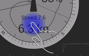
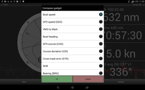
Press and hold on the parameter to change it. The following options are available:
Boat speed
Water speed from NMEA sensor (if NMEA VHW data is enabled). Otherwise boat speed will be equal to GPS speed (SOG).
Graph displays speed changes in 6 minutes time.
GPS speed (SOG)
Speed Over Ground
VMG to mark
Velocity Made Good in the direction of the next mark. Not the same as VMG, which means velocity made good against the wind direction.
Boat heading
Magnetic boat heading from NMEA sensor (if NMEA VHW data is enabled). Otherwise GPS course (COG).
Due to leeway and or current/tide course over ground (COG) may be different.
Graph displays heading changes in 6 minutes time.
GPS course (COG)
Course Over Ground
Course deviation (CDI)
Course Deviation from the previous mark.
Cross track error (XTK)
Distance from your ideal course line.
Shift
Deviation from your heading at this moment.
Bearing (BRG)
Bearing to the Mark.
Turn instruction (BRG-COG)
Angle to the Mark relative to current course.
Distance to mark
Distance to the mark.
Time to Layline
Time to Layline is calculated according to your speed average, course average and wind direction average.
Distance to Startline
Shortest distance to the startline
Track
Distance sailed from the start
Time
Sailing duration from the start
Target speed
Target boat speed and efficiency according to polar.
Apparent wind
Apparent wind speed and direction.
True wind
True wind speed and direction.
Wind average
6 minutes true wind direction and speed graph.
1h Wind average
1 hour true wind direction and speed graph.
Current
Current speed and direction. Calculated as a difference of two vectors 1) boat speed/heading 2) GPS SOG/COG.
Actual/average tuning
Testing parameter for averaging tuning

 Try now
